WOW!!! Revealing info by this investigator
BP Gulf Oil Spill Is Already In Gulf Stream And May Hit North Carolina Beaches Any Day Posted by Alexander Higgins - June 15, 2010 at 7:56 pm - Permalink

Global Map of the Gulf Stream And Ocean Current Flows
As I pointed out in my previous post BP has refused to allow scientists to confirm the origin of an oil plume that was found in the Gulf Stream off the coast of the Florida Keys.
That story was published on June 9th by the St. Petersburg Times which at the time of this post is 7 days ago.
Based on that date oil spill projections show that the the oil already in the Gulf Stream could start washing up on the North Carolina shore any day.
It is entirely possible that by following the flow of the Gulf stream that the oil from the spill could bypass the beaches of the east coast of Florida Georgia and South Carolina and hit North Carolina first.
Lets review some satellite images and a simulation of the path of the spill.
Satellite Images Show The BP Gulf Oil Spill May Have Hit The Florida Keys On May 23rd
According to satellite analysis the BP Gulf Oil Spill seems to have entered the Loop Current on May 17th.
Satellite analysis of the BP Gulf Oil Spill shows that the BP oil slick hit the Loop Current almost a month ago even though the Federal Government, and hence the media, did not acknowledge it.
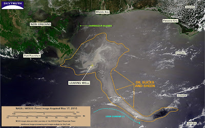
MODIS/Terra image, May 17, 2010, showing slick apparently entrained in Loop Current.
The Loop current is a fast river of water that travels rapidly through the Gulf of Mexico and feeds into the Gulf Stream which travels up the US East Coast.
Since then it appears that the oil slick has continued further south making it as far south as the Florida Keys on May 21st.
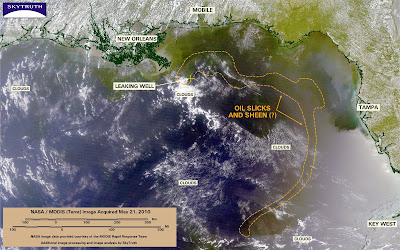
MODIS / Terra satellite image, May 21, 2010.
Apparently it continued further south where part of it went into any eddy that circles the Gulf of Mexico. To my knowledge this continued to happen entirely absent of any sort of acknowledgment by the Federal Government or the media.
http://2.bp.blogspot.com/_edvxM1dkFlo/S_rvFLD59uI/AAAAAAAAAeo/6gKUnYfrz3Q/s400/SkyTruth_dhrig_spill-modis-23may10-aqua-interp.jpgMODIS / Aqua satellite image, May 23, 2010.
On May 27th it appears that the BP spill entered the Florida Keys.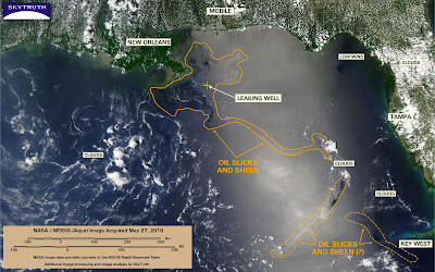
MODIS / Aqua satellite image, May 27, 2010
The confirmation of the oil plume in the Florida Keys by the University of South Florida on June 9th seems to indicate that the satellite analysis made by John Amos of SkyTruth are indeed correct.
Further supporting the satellite analysis are accounts of the oil slick being spotted 12 miles off the coast of FT. Lauderdale, as reported by Palm Beach Times.
The Satellite Photos Match This Simulation Of The Oil Spill Entering the Gulf Gulf StreamBut the progression in that simulation is way too slow.As a starting point, day 74 of the simulation shows the BP oil spill hitting the Florida Keys.
But the satellite images show that May 27th was the actual day that oil slick started to hit the Florida Keys.
That means, based on the satellite analysis, day 74 of the simulation may have actually occurred on May 27th.
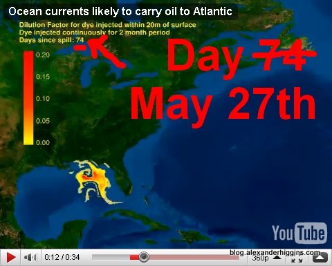
But the analysis of the satellite image on May 27th does say possible oil hitting the Florida keys.
So let us consider the date that the USF scientists confirmed the plume of oil in the Gulf Stream off the southern tip of Florida which was June 9th.
That would indicate that day 74 of the simulation, which is where the simulation hits the Florida Keys, actually occurred near June 9th.From June 9th to the date of this post, June 15th, 6 Days have passed meaning we would be in day 80 of the simulation.
Based On Scientists Confirmation Of Oil In The Florida Keys On June 9th We Are On Day 80 Of The Simulation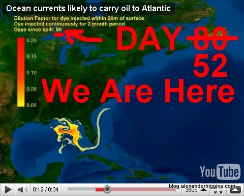
That means there is there are already oil plumes floating off of the coast of North Carolina.
Now if the satellite image does indeed show oil in the keys on May 27th that would mean that we are not on day 80 but on day 93 in the simulation.
Based On Satellite Analysis Of Oil Hitting The Keys On May 27th We Are On Day 93 Of The Simulationhttp://lh4.ggpht.com/_KXlLr4Mnvpo/TBgMeO5TUTI/AAAAAAAADLI/zI3eY6AOtuk/Fullscreen%20capture%206152010%2072714%20PM.jpgIn Either Case Oil Could Start Washing Up On The Beaches Of North Carolina Any Day
How Far The BP Gulf Oil Spill Has Traveled Up The Gulf Stream Is Unknown But
Now that the oil has entered the Gulf Stream this thermal imaging shows just where the Gulf oil spill could eventually travel.

Thermal Image of Gulf Steam Current and possible path of Oil Spill
This graphic demonstrates how the oil could interact with the worlds major ocean currents.
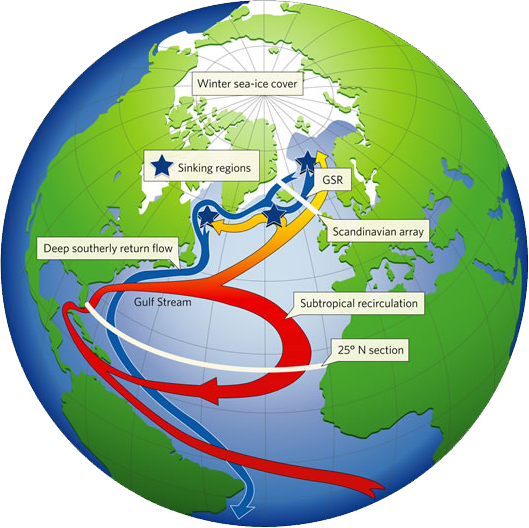
Global Map of the Gulf Stream And Ocean Current Flows
In fact scientists have already warned that the BP Gulf Oil Spill could eventually hit Europe and the Artic.
Unfortunately it seems that scenario is playing out much faster than originally anticipated.
It is even reported that NOAA has stated the BP Gulf Oil spill will make its way up the entire Atlantic coast within a few weeks.
UPDATE: Here Comes Round 2
Another 50 mile oil patch just south of Florida Keys by June 19
Latest HYCOM-GFS oil spill forecast shows a large stretch of oil approximately 15 miles south of the Florida Keys, near Marathon and Big Pine Key by this weekend.